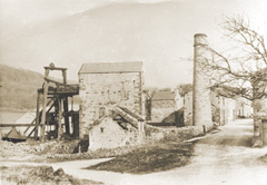
Mill Dam Mine, Great Hucklow. While most of the buildings have been demolished, the building at the back is now Bank Cottage. |
Lead MiningA major lead vein runs from the west at Tideslow through Windmill, then east beyond Great Hucklow and Grindlow to Eyam. The whole area is dotted with mines and shafts that have provided work and income for the villagers on a regular basis from at least the 13th to 20th centuries. There is evidence of lead mining in Hucklow Parish as far back as the 13th century, when the monastic grange at Grindlow belonging to the Augustinians of Lilleshall Abbey was granted mining rights. Production statisics are available for the Tideslow Moor mines near High Rake in 1195 and 1216 to 1249, when some 100 tonnes of lead a year were extracted. At that time, the area excluding Grindlow was under what was known as the Kings Liberty and dues were collected for the crown by the Duchy of Lancaster. This continued until 1690, when the 'lot and cope' was leased to the Duke of Devonshire. Grindlow remained a 'free liberty' and was owned privately by individuals rather than the Crown. The Parish is currently working on a Lead Legacy project, where more information on the impact of lead mining in the area is available. |
Web page maintained by webmaster and hosted at Conformance Ltd, Great Hucklow. Last updated 20 October, 2006 .