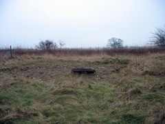
Ore crushing circle at High Rake Mine, Windmill, excavated by the Peak District Mines Historical Society
|
Background to Lead Legacy ProjectThe HeritageThe village of Great Hucklow partially owes its existence to its geological situation on the important lead vein running from Tideslow through to Eyam. It has been established that a Roman road ran from the Roman fort at Brough, through the dale beyond Bradwell and on to the junction with the modern B6049 at Windmill, although none of the Roman lead remains found locally can be directly attributed to the Hucklow vein, it seems reasonable to assume that the Romans must have made use of this resource. There is also documentary evidence of leadmining activity in the medieval period from the end of the 12thC around the area of Tideslow and Hucklow Rakes through to the modern times. Interest in the significance of the Hucklow rake has been raised by extensive archaeological excavations to the west of the village of High Rake Mine by the Peak District Mines Historical Society. It seems that there were up to at least twelve mines on the vein in the Hucklow Liberty. Some of these can still be traced - people with local knowledge can still recall details about locations etc, but they are becoming fewer and fewer - it would be prudent to record their knowledge while they are still with us. Vegetation especially in the woods is also fast concealing traces of these mines, as is agricultural use and building developments elsewhere. There is good photographic evidence for High Rake and Mill Dam mine. The present Mill Dam Mine is owned by Glebe Mines (originally Laporte) and closed in 1999, but possibly about to re-open, brings us up right up to present time. The remains of Silence Mine, which has not yet been archaeologically excavated, and its spoil heaps to the west of the village are now threatened by scrub and by an unofficial off-road motor-cycle track. These remains are considered by local mining experts to be of significant archaeological interest and the land to the east of it is important for its biodiversity. The Peak District National Park Authority Vision Project are currently hoping to make the area a nature reserve which will eventually be owned and managed by Great Hucklow and Foolow Parish Councils. NB: 1. Hucklow Wood: the lower half below what is known as 'the Hollow Road' is managed by the Peak National Park. It grew on top of the spoil heaps from the lead mines and conceals much evidence although some is still discernable. There is a small information board at the entrance to the wood but no details about the lead mines in the area. 2. The spoil heaps and mines on the north side of the road from Windmill were destroyed by a quarry which in turn was filled in by rubble. This is overgrown but owned by the Parish Council. Back to top |
Web page maintained by webmaster and hosted at Conformance Ltd, Great Hucklow. Last updated 3 May, 2010 .