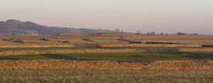
The surface geology of the area shows gently undulating fields on carboniferous limestone in the foreground, separated by limestone walls. In the background, Hucklow Edge can be seen. This is capped with Millstone Grit with underlying shales. |
GeologyThe geology of the Hucklow area is very interesting. Windmill, Little Hucklow and Coplow Dale are located on carboniferous limestone and demonstrate a typical 'White Peak' landscape. Great Hucklow and Grindlow lie at the junction of the limestone with overlying shales. Further up Hucklow Edge, the geology changes again, the Edge being capped with Millstone Grit. The shales and grits give a characteristic 'Dark Peak' landscape. The geology has influenced building materials, buildings in the White Peak villages being primarily built of limestone, with gritstone also being used in the other villages. The different underlying rocks have a profound effect on the landscape. The shales are prone to landslips and there is a major zone of slippage in the Burrs Mount area visible from Windmill and Great Hucklow. There is a spring line where the shales meet the limestone. Before the shales and Millstone Grit was deposited, the carboniferous limestone domed up (the 'Derbyshire Dome'). The limestone became fissured and faulted when this happened, and the cracks became filled with mineral-rich veins containing galena, fluorspar and barytes. Galena is a major lead ore, and there has been lead mining in the area for many centuries. The vein running under Hucklow Edge from Great Hucklow towards Eyam was mined for fluorspar as recently as the 1990s. |
Web page maintained by webmaster and hosted at Conformance Ltd, Great Hucklow. Last updated 3 May, 2010 .